

The team led by Dr. Huang Wenjiang at the Aerospace Information Research Institute, Chinese Academy of Sciences, has been addressing the significant global need for monitoring, forecasting, and controlling vegetation diseases and pests. They have conducted research on monitoring and forecasting methods for vegetation diseases and pests based on high temporal and spatial resolution remote sensing data. The team has developed the Vegetation Pest and Disease Remote Sensing Monitoring and Forecasting System. Moreover, they have produced specialized maps and scientific reports in both Chinese and English for major diseases and pests affecting key crops such as wheat, rice, corn, and soybeans, covering 38 countries worldwide. Their work has enhanced the efficiency of disease and pest monitoring, improved the accuracy of monitoring and forecasting, and increased the continuity and effectiveness of their products and services. Through deep collaboration with government departments and international organizations, the team has facilitated the global implementation of their system and products in key countries and regions. Their achievements have been cited and adopted over 200 times by international organizations such as the Food and Agriculture Organization of the United Nations (FAO), the Global Biodiversity Information Facility (GBIF), and CAB International (CABI). Additionally, government departments and institutions such as the Italian National Research Council, the UK's Newton Fund, Agriculture and Agri-Food Canada, the Ethiopian Space Science Society, the Chinese Disaster Prevention Working Group in Pakistan, and Pakistan's PMAS-Arid Agriculture University have utilized these results. The team has promoted the application of remote sensing monitoring and forecasting technology for diseases and pests in countries including Kenya, Somalia, Yemen, Ethiopia, Pakistan, India, and Nepal, supporting the scientific control of over 20 million hectares (approximately 300 million mu). This has effectively supported the scientific control of diseases and pests, ensuring food security and regional stability.
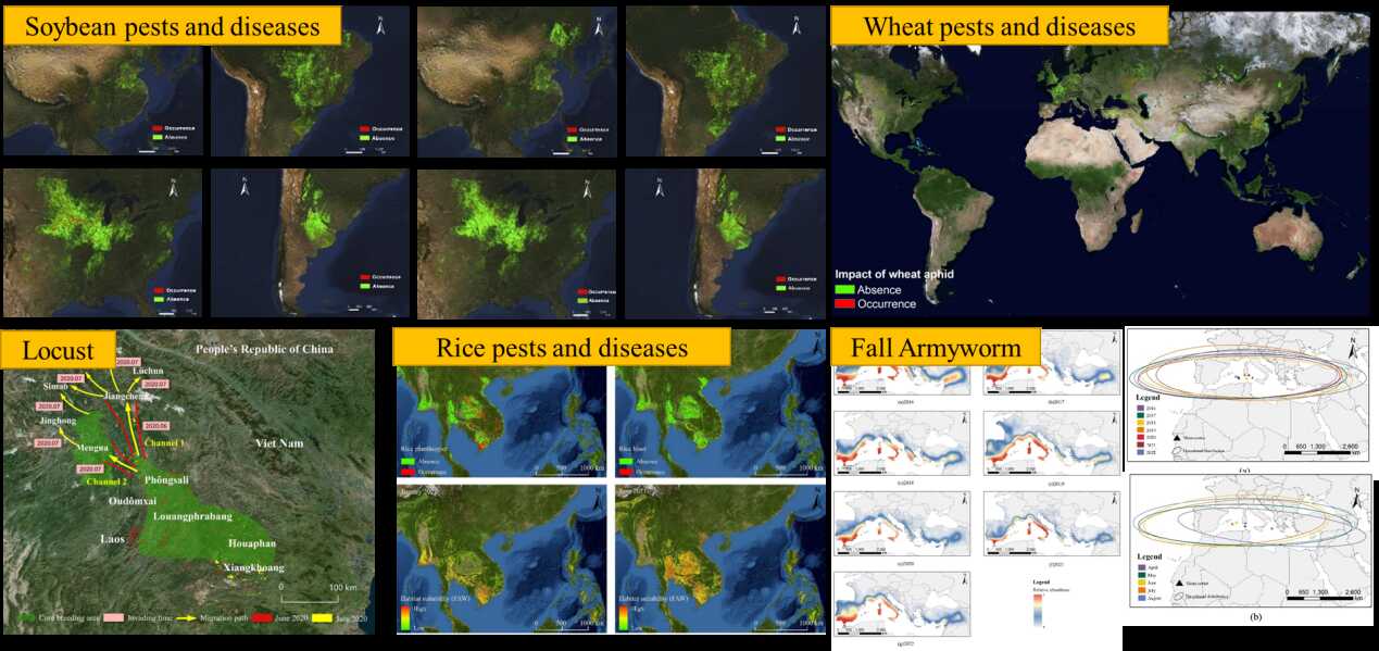
The global crop pest and disease remote sensing monitoring and forecasting data is produced based on multi-source, multi-scale, and multi-mode data. This data can serve the efficient control of crop pests and diseases worldwide, providing spatial information support for the joint prevention and control of major crop pests and diseases by multiple countries. Additionally, by integrating geographical, population, economic, and transportation data, this dataset can effectively serve crop disaster loss assessments and holds significant reference value for the stability of the international food market.
Academic paper
Wang J, Huang Y, Huang L, et al. Migration risk of fall armyworm (Spodoptera frugiperda) from North Africa to Southern Europe[J]. Frontiers in Plant Science, 2023, 14: 1141470.
Huang Y, Lv H, Dong Y, et al. Mapping the spatio-temporal distribution of fall armyworm in China by coupling multi-factors[J]. Remote Sensing, 2022, 14(17): 4415.
Sun R, Huang W, Dong Y, et al. Dynamic forecast of desert locust presence using machine learning with a multivariate time lag sliding window technique[J]. Remote Sensing, 2022, 14(3): 747.
Patent
1. Dong Yingying, Zou Yuzhen, Li Xueling, Liu Linyi, Huang Wenjiang, Zhao Xing; Method and Device for Predicting Desert Locusts, Application Date: 2023-03-20, China, ZL202310246264.4. Authorization Date: 2023-05-10.
2. Liu Linyi, Dong Yingying, Huang Wenjiang; Method and Device for Crop Disease Monitoring, Application Date: 2020-04-24, China, ZL202010331417.1. Effective Date: 2022-11-01. Patent Term: 2020-04-24 to 2040-04-24.
Data Access Link
https://data.apps.fao.org/map/catalog/srv/chi/catalog.search#/metadata/c3916b80-ec82-4576-87ab-63d608e75c1d
https://www.gbif.org/dataset/dfa36691-529b-43b6-9e61-b76275d94ffc
http://map.rscrop.com/
http://desertlocust.rscrop.com/
Liu Linyi, Ph.D.
Assistant Researcher
Aerospace Information Research Institute, Chinese Academy of Sciences
Dr. Liu Linyi has long been dedicated to pioneering theories and scientific methods in remote sensing monitoring and forecasting of crop diseases and pests. He has led the national key R&D project "Integrating Multi-source Earth Observation Data for Global Crop Pest and Disease Dynamic Monitoring and Early Forecasting" and received funding from the Special Research Assistant Project of the Chinese Academy of Sciences. He has published 23 academic papers and filed or been granted 9 patents domestically and internationally. Dr. Liu has overcome technical bottlenecks such as coupling disease and pest mechanism models with remote sensing data and efficient computation of disease and pest monitoring and forecasting models. He has established a personal innovative research system focused on disease and pest monitoring and forecasting. His achievements include the Innovation Award at the 12th Da Bei Nong Science and Technology Award and the 2022 China Remote Sensing Outstanding Achievement Award.
As a core developer, Dr. Liu contributed to the creation of the Vegetation Pest and Disease Remote Sensing Monitoring and Forecasting System, which enables intelligent production of disease and pest reports from data to products. This system has advanced the application of spatial information technology in crop pest and disease monitoring, forecasting, and controlling. His achievements have received directives from national leaders 8 times and have been continuously adopted and operationalized by the General Office of the CPC Central Committee, the General Office of the State Council, the Ministry of Agriculture and Rural Affairs, the Ministry of Science and Technology, the National Forestry and Grassland Administration, FAO, GEO, and GBIF.
Liu Linyi 13810333005
https://news.sciencenet.cn/htmlnews/2018/6/414667.shtm


